Flood Damage Assessment
Flood damage assessments are an example of how customers use Mobile Data Anywhere to create mobile data collection tools to collect data related to, and report on, flood and inundation damage to infrastructure and assets caused during and after a flood incident.
During a natural disaster such as a flood there is an immediate requirement to mobilise a team of people quickly to identify and assess initial areas of damage and high priority damage. Once the high priority damage has been assessed, more detailed assessments need to be performed to get a picture of the extent of the damage to . And from this detailed assessment the cost of repair to the damage can be estimated more accurately.
In the first few days of the disaster little knowledge of the actual extent of the damage is known until people get on the ground and start assessing damage. It is necessary to have data feeding back in real-time so that the people managing the teams in the field can see where the problem areas are and where resources need to be deployed.
The data that is collected in the field needs to be monitored in real-time to ensure it is high quality and consistent.
The Solution
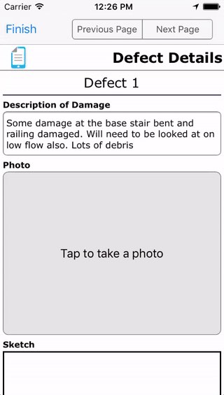
A comprehensive tool like the one shown below can be created rapidly using the Mobile Data Anywhere platform. This data collection app allows a team of assessors to be deployed to the field quickly to start assessing damage.
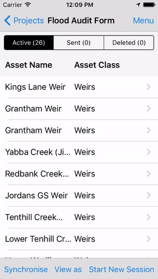
Typically in a disaster response such as a flood it is imperative to get on the ground and collect data quickly. The mobile tool that is developed to perform the assessment can be evolved and iterated on quickly and re-deployed to the people in the field as they are working. The important data that needs to be collected includes the GPS location, photos with annotations, descriptions and a quantified assessment of the damage.
Below is a view of the data collected and what users will see back in the office the web portal.

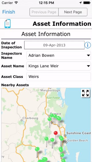
Once the initial damage assessment is complete a more comprehensive and thorough assessment of the damage can be performed. At this stage of the flood damage assessment it is very useful to have predefined data uploaded into the mobile form, such as Asset Categories, Asset Id’s and Asset Locations. This data can be uploaded into Drop lists. The data in the Drop lists can also be hierarchical so that Drop lists can be used to filter other Drop lists.
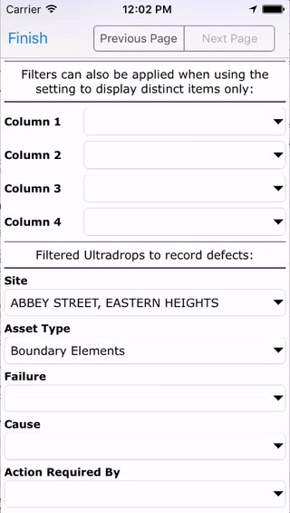
If the coordinates of the assets in the field are know it is also possible to display known assets on a map so that the assessor can select an existing asset from a list that is on a map based on where they are currently located.
When collecting data photos can be taken of the damage and the images can be annotated by drawing on the screen.
During a natural disaster such as a flood the ability to monitor the data in real-time for quality assurance and to determine where to deploy and concentrate resources in the field is critical.
By viewing the data on a map, displaying critical information on a dashboard and running exception reports, the impact of the flood assessment can be monitored in real-time. This enables resources to be managed effectively and to make sure that the data that is collected is of high quality.
Once the detailed damage assessment has been completed reports can be generated and presented to the asset owners. This can be done with a very basic excel export of the raw data. Or a simple export of the data to a KML file that can be loaded into a GIS application.
Below is an example of a KML export in Google Maps.
Complex reports can also be created using the Reporting tool, where multiple data sources can be brought together to perform complex reports. Below is an example report with a line per assessment with images and a summary of the data.
Mobile Data Anywhere can be used to:
- quickly create comprehensive mobile data collection apps to perform preliminary flood damage assessment as well as comprehensive detailed flood damage assessment.
- provide real-time up to date analysis of the data that is being collected.
- have predefined data from drop lists in the forms and Geospatial views of assets for easy selection.
- generate real-time comprehensive dashboarding and reporting to ensure high quality data collection throughout the assessment process.
- generate final reports in raw Excel or complex custom reports
Create powerful mobile forms for your business in minutes